![]()
GIZA'S
COSMIC BLUEPRINT
PART
TWO - THE SEARCH FOR EGYPT'S MOUND OF CREATION
Does the Cygnus-Giza Correlation Reveal the Whereabouts of Egypt's Greatest Lost Tomb - That of Osiris? Read the Findings and Decide for Yourself
Part
One of Giza's Cosmic Blueprint demonstrated how the three "wing"
stars of the Cygnus constellation correlate near perfectly with the positions
of the Pyramids of Giza, both in a vertical and horizontal plane. This raises
the question of whether the Giza pyramid field was created to conform to a grand
design, a structral blueprint, involving the stars of Cygnus in their capacity
as representations of the celestial womb of ancient Egypt's primeval sky-goddess.
The
natural assumption is to see the Cygnus-Giza correlation, with its related geometry,
as focused primarily on the Giza pyramid field. Yet this draws the eye away from
the correlation's true point of foundation, which is the centre of the circle
defined by the arc created by the peaks of the three Giza Pyramids. It is from
this convergence point, some 2800 m (one and three quarters miles) southeast of
the plateau, that the three Cygnus wing stars would have been seen to set into
the apexes of their corresponding pyramids during the Pyramid Age. So what is
to be seen at this place of convergence in the Nile valley basin? Does it have
any importance in its own right?
The
Zaghloul Street Mound
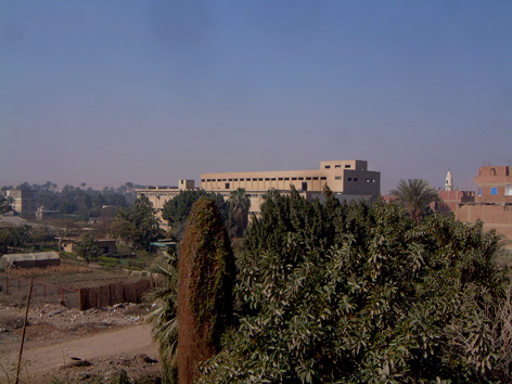
A quick look on Google Earth shows that the Cygnus-Giza convergence point falls south of the village of Kafr el-Gebel, in the vicinity of an old factory on the west side of Zaghloul Street, which runs between the eastern approach to the Pyramids in the north and the Eastern Ring Road to the south. The factory, a stark concrete monstrosity, belonged to a clothes manufacturer named Shorbage, although today it lies empty, guarded 24/7 by a local security firm.
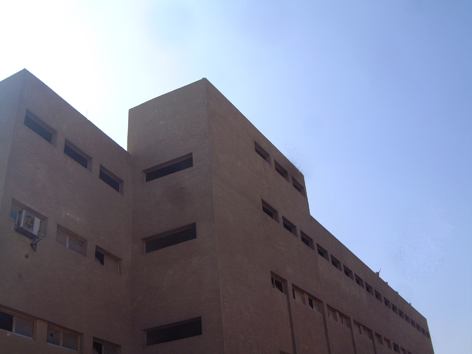 |  |
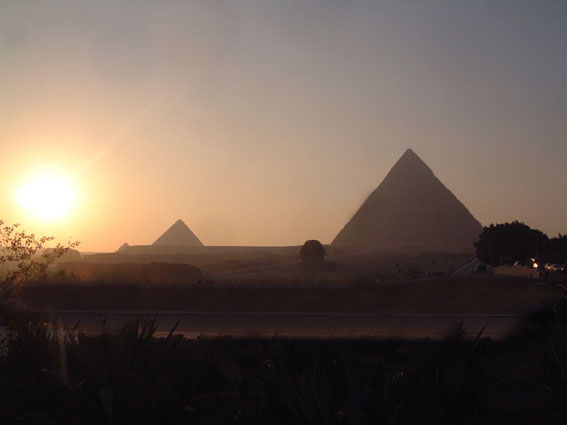
Two views of the Shorbage factory on Zaghloul Street, south of Kafr el-Gebel. Left, the bleak starkness of this building becomes apparent. Right, the view of the factory from an elevated position on the opposite side of Zaghloul Street, looking northwest towards Giza, which from here is about 3 km distant. The Great Pyramid and Second Pyramid are just visible beyond the foggy haze. The Third Pyramid is hidden behind the factory (pics: Andrew Collins).
On
the ground the convergence point is marked by a roughly circular mound sitting
on a slight rise. Its reaches a height of 20.7 m (68 feet) above sea-level, with
the height of the surrounding landscape being on average 15-18 m, or 49 to 59
feet. In size the mound is approximately 100 m north to south and 50 m east to
west. Whereas the rise on which it sits is almost certainly natural, the north-south
orientation of the mound hints at something more. At worse it is a suitable observation
site for gazing across to the Giza Pyramids. Yet just maybe it constitutes the
vestiges of a kom, or occupational mound, now greatly reduced due to erosion.
Was it upon this Zaghloul Street mound, as we shall call it, that the observer
would have stood to watch the Cygnus wing stars setting down into their respective
pyramids? It makes complete sense. Yet before we get too ahead of ourselves, we
should stop to examine what is known about this general area from ancient sources.
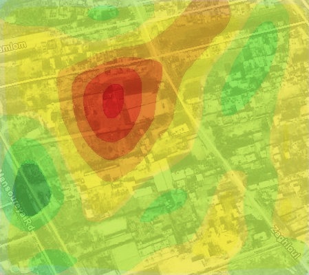 | 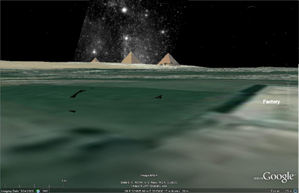 |
Above left, the heights above sea level around the convergence point of the circle made by the arc of the Giza Pyramid peaks, with the colour sequence running from the lowest to highest ground being green, yellow, orange and red, ranging in scale from 15 to 20.7 m. As we can see this reveals a notable mound immediately west of the Shorbage factory building. (Pic: Rodney Hale/Google Earth). Above right, view of the Cygnus wing stars setting into the peaks of their corresponding pyramids as viewed from the convergence point beyond Kafr el-Gebel. Notice the aforementioned mound to the left (i.e. west) of the factory building (here seen in flat plan). (Pics: Rodney Hale/Google Earth).
Busiris
- the House of Osiris
Classical writers speak of the existence near the Pyramids of Giza of a village called Busiris, which is thought to have been sited somewhere in the vicinity of Kafr el-Gebel (the pyramid field of Abusir, some 13 km (8 miles) south-southeast of Giza, also takes its name from Busiris). Considerable evidence of dynastic activity has been found in the vicinity of the local Islamic cemetery and market square, which lie about 0.9 km (half a mile) north of the Zaghloul Street mound and about 2 km (1.2 miles) away from the plateau. Indeed, it had been Dr Zahi Hawass's intention to begin excavations in the vicinity of the cemetery, much to the consternation of local residents. This is unlikely now to take place.
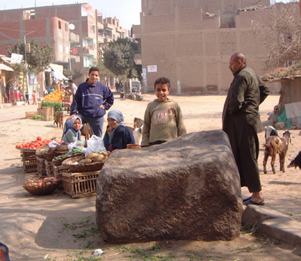 | Fashioned block of Aswan granite lying in the market square at Kafr el-Gebel, close to the convergence point/Zaghloul Street mound. Inscriptions found locally seem to suggest this area was known as Upper Rostau, or Giza south (pic: Andrew Collins, 2007). |
Like its better known counterpart in the Nile Delta, the Memphite Busiris honoured the cult of Osiris, since the name means "House of Osiris" (pa-asar). Almost certainly it was the location of a perceived Tomb of Osiris, a fact made clear by the discovery of New Kingdom inscriptions in the area of Kafr el-Gebel, which talk of the location under the name Upper Rostau (Lower Rostau being the pyramid field itself) or Giza south, and indicating the presence thereabouts of a structure called the Shetayet, quite literally the "Tomb of God". This was presided over by Sokar, a very ancient falcon-headed god of death, decay and the darkness of the tomb, who was a personificatin of the sun at midnight, i.e. the sun in the underworld. His cult thrived across the Memphite necropolis from a very early age through to the Old Kingdom when it was absorbed into that of Osiris, the ancient Egyptian god of the afterlife. Afterwards the god was referred to as Sokar-Osiris, or quite simply Osiris (similar absorptions of local funerary deities took place at other cult centres in Egypt).
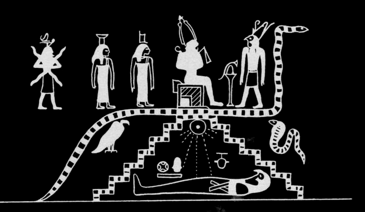
Sokar-Osiris as a mummy inside a stepped primeval mound, symbolising the womb of creation. Here he is associated with the deceased achieving rebirth in the Duat-underworld under the light of the midnight sun. Above the mound we see a huge snake, a protector of the dead king when in this realm, as well as the pharaoh as Osiris greeted by the god Horus.
The
Hidden Cave of the God Sokar
Sokar was also the guardian of a part of the Duat-underworld, the realm of the dead, special to the Memphis necropolis (Saqqara is named in his honour). This, as we saw in Part One, was a domain seen as both celestial, existing within the body of the sky-goddess Nuit, and chthonic, in that it extended beneath the earth. It was into this tunnel of darkness that the sun-god, named now as Amun-Re, and occasionally Osiris, was thought to journey at night, from sunset to sunrise, travelling inside a boat that would traverse underground waterways. This nocturnal journey was divided up into twelve divisions, or hours of the night, each with their own gates, guardians, monsters, trials and tribulations, which would have to be approached and dealt with in the correct manner. Since the soul of the deceased was equated with the dying sun-god spell books were created for its express use when in this underworld. These would be written on the walls of tombs, on sarcophagi and coffins, and eventally on papyri scrolls, which were interred alongside the body of the deceased.
One such funerary text was The Book of That Which is in the Duat, or just simply the Am-duat, which dates to the New Kingdom period. Its Fourth and Fifth Hours of the Night, which constitute the time approaching the middle of the night, are interesting indeed, for it was here that the midnight sun received new life. It should be remembered that the Duat through which the sun passed was conceived of also as the body of Nuit, with conception and gestation occuring in her womb, which became synonymous with the concept of the tomb, sarcophagus and coffin, where transformation of the deceased took place. Thus the Fourth and particularly the Fifth Hour of the Night had to have been equated with the womb of Nuit.
The Fourth and Fifth Hours of the Duat bore the name Rostau, or Re-stau, which just happened to be the ancient name for the part of the Memphite necropolis known today as Giza - this being Lower Rostau (or Giza North), which was the current pyramid field, and Upper Rostau (Giza South), which was the area around what is today Kafr el-Gebel. Rostau itself means the "mouth of the passages", or the "entrance to the corridors", leading to the so-called kingdom of Sokar, the part of the Duat special to Memphis (other "hours" of the Duat were linked to cult centres in the south of the country, in Heliopolis northeast of Memphis and in the Nile Delta where, on its eastern fringes, the sun finally gained release from the underworld as it was reborn on the eastern horizon.
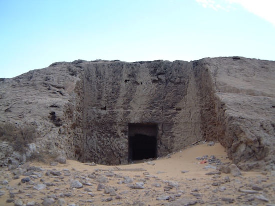
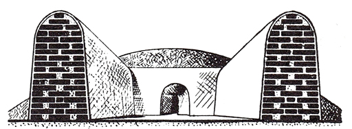
Thus it would appear that Rostau, modern Giza/Kafr el-Gebel, was thought to be the entrance into the Duat of Memphis, which was known also as Amenti, of the Hidden Circle of Amenti. If such a place existed on a physical level then the most obvious candidate would have been the entrance to the cave complex rediscovered in 2008 by Nigel Skinner Simpson and the author in the plateau's north cliff. This is accessed via a substantial tomb (NC2, a.k.a. the "Tomb of the Birds") with an enormous rock-cut facade (see picture). The sepulchre possesses a huge subterranean network of chambers linked by a central gallery along the centre of which is a line of hewn pillars, the whole thing being accessed via twin staircases located just inside the tomb's twin-lobed antechamber.
 |
|
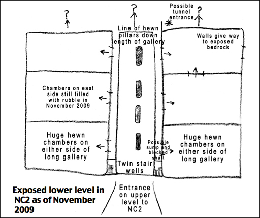
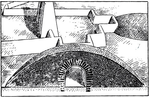
The entrance to Giza NC2 (north cliff 2), otherwise known as the "Tomb of the Birds" due to its apparent role as a bird necrpolis. This was the first picture taken of the site by the author in January 2007, fourteen months before he and Nigel Skinner Simpson and their team rediscovered its extensive cave system. Right, the lower level of Giza NC2 as revealed by clearance work undertaken by Dr Zahi Hawass's team in 2009. A report of their findings has yet to be published. (Pics: Andrew Collins)
To date Giza NC2 has produced no evidence of burials, suggesting that its cave passages might have had a more symbolic function. Written evidence from the mid nineteenth century indicates that the tomb was used as a bird necropolis, which might just link to the surmise that the caves were believed to lead to Rostau, the domain of Sokar in the Duat-underworld. Similar beliefs might have surrounded the 60 m (200 feet) tunnel discovered recently in King Seti I's tomb (KV17) in the eastern Valley of the Kings. This, so Dr Hawass speculates, was perhaps seen as a symbolic path to "the hidden cave of the god Sokar" in the Duat-underworld.
Giza NC2's cave complex is the only natural system ever to be found in connection with an ancient Egyptian tomb, strongly indicating its connection with the original concept of the Duat-underworld, and in particular Rostau's kingdom of Sokar.
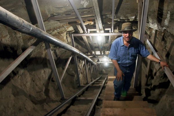 |  |
Dr Zahi Hawass (left) emerges from the 60 m tunnel discovered in Seti I's tomb, which he now believes was a symbolic route to the Duat-underworld, guarded by a huge multi-headed snake (right), depicted on a wall inside the tomb. Dr Hawass speculates that this part of the Duat was "the hidden cave of the god Sokar" (Pics: SCA/Heritage Key/National Geographic).
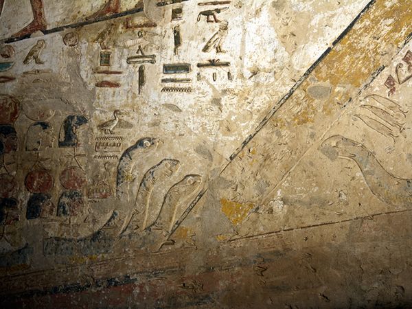
According to the Am-duat text, the approach to the domain of Sokar in the Duat of Memphis was via "the road to the secret things of Rostau", suggesting that some kind of cave-like tunnel really was thought to extend beneath the Memphite necropolis. Pictures of the kingdom of Sokar show a primeval mound or island surrounded by the waterway that was seen to flow through the Duat-underworld. On this mound Sokar is seen standing on an enormous multi-headed serpent, clearly a guardian of this chthonic realm associated with the god himself. The implication is that this primeval mound was thought to exist at Giza-Rostau.
| Right, the falcon-headed god Sokar stands upon a huge multi-headed snake, which lies within an oval symbolic of an island in the waterway that passes through the Duat-underworld. Above this island is a mound from which protrudes the head of a woman identified in the Am-duat text as the goddess Isis. The mound and island, being in alignment, are very likely aspects of the same physical feature or location. Above the head of Isis is the Khepri beetle, symboling the renewal of the midnight sun. It emerges from the base of a bell-shaped object, on which two birds perch. This strange object might well represent what was known in Greek mythological tradition as an omphalos, or cosmic navel, symbolising the centre of the physical universe. If so, then the mound and island beneath are almost certainly symbolic of the mound of first creation which arose out of the primeval waters at the beginning of time. | 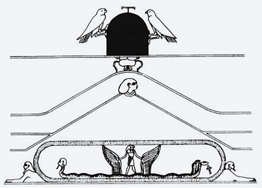 |
Primeval
Mound of Creation
A similar primeval island or mound is mentioned in
the building texts found on the walls of the Ptolemaic Temple of Horus at Edfu
in southern Egypt. Although these texts, which speak of the mythological foundation
of the first primeval domains in Egypt, are only about 2,000 years old, they are
said to be derived from much older written sources dating back to primordial times.
Here this island of First Creation (zep tepi) is spoken of as the domain
of a primeval god who initially took the form of a serpent, but then later became
a bird god, seemingly a falcon with possible links to the god Sokar. After this
primeval god is drowned during a cataclysm, the mound becomes his tomb, the first
one in Egypt.
Egyptologist Eve Reymond in her extensive commentary on the Edfu building texts entitled The Mythical Origin of the Egyptian Temple (Manchester Univ. Press, 1969) shows that in some of the texts this primeval mound surrounded by water, the resting place of the first god to die, was identified with the Tomb of Osiris. This links with the fact that symbolic Tombs of Osiris like the cenotaph of Seti I in Abydos and perhaps the so-called Osiris Shaft at Giza feature raised central areas surrounded by water as if to emphasise their connection with the primeval mound of creation.
More crucial to this debate is the fact that the Edfu Bulding Texts make it clear that the primeval mound or island, which became the Tomb of Osiris, was geographically located north of the city of Memphis, i.e. in the area of Kafr el-Gebel and the Giza plateau. One of the oldest forms of Sokar's name is shown in inscriptions as a falcon standing upon an oval, which is yet another allusion to his guardianship of the primeval mound as the original Shetayet, or Tomb of God.
Although
this primeval mound housing a tomb might have come to be identified with a prominent
hill close to the Giza pyramid field, most probably Gebel Gibli, which as we saw
in Part One would seem to have been known as the "Splendid Place of the First
Time", it might originally have been located much closer to the Nile, perhaps
even in the river itself. The Nile valley basin would always have been flooded
for around three months a years following the annual Innundation. Could this primeval
mound have been located in the vicinity of the Zaghloul Street mound beyond Kafr
el-Gebel, the convergence point in the Cygnus-Giza correlation, towards which
the three Giza Pyramids seem to honour with their graceful arc?
The Rivers of Hades
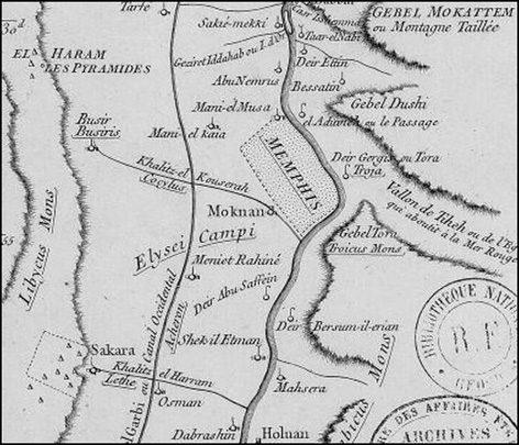
There is more evidence that the Tomb of Osiris was seen to exist in the vicinity of Kafr el-Gebel. A map of Cairo, Memphis and their environs by the French geographer and cartographer Jean Baptiste Bourguignon d'Anville (1697-1772) shows Busiris (additionally named as "Busir") a short distance southeast of the Giza plateau. Overlaying d'Anville's map on Google Earth reveals not only the accuracy of the Frenchman's surveying and map-mapping skills, but also, more importantly, that his Busiris is located in the same general area as the convergence point in the Cygnus-Giza correlation.
More intriguingly, d'Anville's Busiris is shown at the western termination of a tributary originating from the Nile river. This tributary bears the legend "Khalitz-el Kouserah Cocytus", with Cocytus being the name of one of the five Rivers of Hades, the Greek underworld.
Why should d'Anville have given the tributary this mythological name? Was it just a flight of fancy, or was there some meaning behind its presence on his map? A closer look reveals that he allotted mythological names to other topographical features locally. A north-south flowing canal that crosses the "Cocytus" bears the name "Acheron", which is another river of Hades.
In addition to this, a tributary connecting Saqqara to the Nile is named as the Lethe, yet another river of Hades, while the whole general area between the Cocytus and Lethe rivers is marked as "Elysei Campi", the Elyian Fields, the name given in Greek myth to the realm of the dead in the extreme west. This seems appropriate, since the entire west bank of the Nile was essentially once big necropolis, seen as Amenti, a visible land of the dead. Completing the Greek mythological landscape is that the Nile itself was associated with the River Styx, over which the dead had to be ferried in order to reach the Elysium Fields, i.e. Amenti.
 |
|
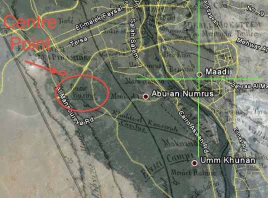
Section of the map of Cairo, Memphis and their environs by French geographer and cartographer Jean Baptiste Bourguignon d'Anville (1697-1772). Notice the placement of Busiris at the end of the Cocytus river. See also the Lethe river connecting with "Sakara", as well as the north-south running Acheron river and the placement of the Elysei Campi, or Elysian Fields. The Nile flows north to south, constituting the River Styx over which the dead were ferried in Greek myth. The position on the map of the city of Memphis is in theory misplaced, since this is today associated with the village of Mit Rahini, marked on the map a little further south under the name "Meniet Rahine". Right, section of the d'Anville map with Google Earth overlaid as best as possible. Note how close "Busir/Busiris" (ringed in red) is to the convergement point of the Cygnus-Giza correlation, and also the centre of the circle made by the arc of the Pyramid peaks (circled and arrowed).(Pics: Bibliotheque Nationale/Janet Morris/Rodney Hale/Google Earth).
Although this transfer of Greek mythological names to the Memphite landscape might at first seem like whimsical fancy on the part of d'Anville, it is a fact that in Roman times the original Elysian Fields, complete with the various otherworldly rivers, was located in Egypt. This was noted, for instance, by the Roman writer Diodorus Siculus:
Now he calls the river "Oceanus" because in their language the Egyptians
speak of the Nile as Oceanus; the "Portals of the Sun" (Heliopulai) is his
name for the city of Heliopolis; and "Meadows," [i.e. the Elysium Fields] the mythical dwelling of the dead, is his term for the place near the lake which is called Acherousia, which is near Memphis, and around it are fairest meadows, of a marsh-land and lotus and reeds ... And near these regions, they say, are also the "Shades," which is a temple of Hecate, and "portals" of Cocytus and Lethe, which are covered at intervals with bands of bronze. (Diodorus Siculus, Library of History, Book i, 96: 7-9).
Moreover, Diodorus tells us that this knowledge of the realms of Hades in
Egypt was carried to Greece by none other than Orpheus, the divine poet, following
his own sojourn in the underworld! Presumably what this means is that Orpheus
gained his information whilst on a visit to the city of Memphis.
All this is of relevance for it is said that it was along the Cocytus, the "river of wailing", that the body of the god Adonis was transported by boat to its final resting place as mourners lamented and wailed uncontrollably on its banks. Significantly, the cult of Adonis, the Phoenician god of death and resurrection, was integrally bound up with that of Osiris. Indeed, in the city of Byblos, where the body of Osiris was said to have been washed ashore in one legend, Adonis and his Egyptian counterpart were synonymous with each other.
So is it possible that the Frenchman d'Anville, who visited Egypt during the eighteenth century, learned of a lingering legend that spoke of the body of Osiris or Adonis being carried by boat along the Cocytus to its final resting place at Busiris, which we know means the House of Osiris? Was this some sort of distorted memory of the presence of a primeval mound that housed some kind of Shetayet, or Tomb of God?
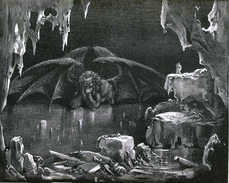 | Victorian artist Gustav Dore's depiction of the Cocytus river from his illustrated edition of Dante's Inferno. |
The
Shabaka Stone
Strengthening the case still further is the so-called Shabaka Stone, on which is an inscription dating to the reign of the Kushite king Nerekare, a.k.a. Shabaka, who reigned c. 711-697. The text, which claims to have come from a much earlier original, contains the oldest account of what is known as the Memphite theology - an account of the gods of Memphis. It alludes also to the drowning of Osiris at the hands of his scheming brother Set, stating that once the body had been retrieved it was interred in a place presided over by Sokar.
The location of the body's retrieval is given as Ayan, the ancient name of Gebel Tura, a rocky region on the eastern banks of the Nile between Cairo and Memphis, where the high quality limestone used to complete the Great Pyramid was obtained. It was at Ayan also that the Shabaka Stone tells us that Set and Osiris's son Horus agreed to divide up the country. Horus would rule Lower Egypt, while Set would take control of Upper Egypt - the place where this agreement was made becoming the division between the two lands. This, however, was before the earth-god Geb intervened and decided that Horus should get the whole of the kingdom, with the slayer of his father getting nothing.
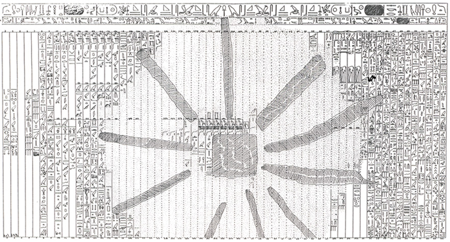
Illustration showing the text on the Shabaka Stone, which is housed today in the British Museum.
So where exactly was Osiris's final resting place? If near Ayan, north of Memphis, the place of demarcation between Upper and Lower Egypt, then this is significant, for the northern edge of Gebel Tura is at the same latitude as the Zaghloul Street mound, which lies on the opposite side of the Nile, in its fertile valley basin. This area corresponds pretty well with d'Anville's geographical positioning of Busiris, which lies at the western termination of the Cocytus river, where Adonis was laid to rest after his journey by boat. Is it possible that a tradition regarding the transportation of Osiris's body along this waterway to Busiris lingered until fairly recent times? Was it somehow linked with the concept of the sun-god, as Amun-Re or Osiris, being carried by boat through the Duat of Memphis, the Hidden Circle of Amenti, to his place of rebirth?
If it was, then it makes sense of why the Zaghloul Street mound acted as both the centre of the arc circle created by the peaks of the Giza Pyramids and the convergence point of the Cygnus-Giza correlation. Here somewhere was a primeval mound, or island, that Egypt's first mortal god, later remembered under the name Osiris, was lain to rest and began his journey back to the celestial womb of Nuit, personified in the sky as the stars of Cygnus and the Milky Way. Should all this prove to be so, then clearly the mythological traditions that preserved this knowledge across the millennia had become distorted, confused and even contradictary. Yet somehow at the root of all this seems to be information regarding the existence at Giza-Rostau, and most obviously in the vicinity of Kafr el-Gebel, of an original primeval mound or island of immense antiquity.
 |  |
Two
views of a predynastic sanctuary focused around a primeval mound,
based on discoveries at Medamud, southern Egypt.
Taken from R. A. Schwaller de Lubicz The Temple of Man (1981). Was
the Tomb of Osiris, the original Shetayet, of similar appearance?
Examining the Zaghloul Street Mound
So if the Zaghloul Street mound was once a kom, or occupational mound, then what was here in the past? The rise is roughly 100 m from north to south and 50 metres from east to west, and so could well constitute the presence of a north-south orientated structure of some kind. Adding weight to this idea is the fact that after examining Google Earth satellite images going back to 2003 Rodney Hale believes he has identified a linear feature delineated by soil and fauna discoloration just to the west of the Shorbage factory building. It runs for a distance of at least 50 m, and appears to be aligned north-south. It also cuts across existing property boundaries, so is unlikely to be a modern feature.
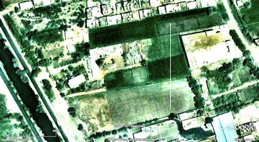 | The north-south line marks the position of the linear feature noticed in the vicinity of the Zaghloul Street mound, immediately west of the Shorbage factory (the building with the white roof). It could, of course, be a natural discolouration of the fauna. On the other hand it might be evidence of an artificial structure of dynastic origin. Defocus your eyes to fully appreciate this linear feature (pic: Rodney Hale/Google Earth). |
Very often enclosure walls surrounding dynastic structures are aligned north-south, as is evidenced from a quick glance at any pyramid field. Beyond this it would be foolish to speculate further. It might be that the perceived line is simply a trick of the eye, or a natural feature of no value to our debate. On the other hand, we must not lose sight of the fact that the real Shetayet, or Tomb of God, presided over by the god Sokar, was thought to exist in this same area, somewhere southeast of the Giza pyramid field.
Final
Thoughts
My sense is that prior to the Pyramid Age there were a number
of raised observational mounds in the area around Giza and Kafr el-Gebel, some
natural and others artificial. I believe they included the knoll out of which
the Sphinx was carved, Gebel Gibli, the rocky mound on which the Second Pyramid
was built, and the Zaghloul Street mound. There would have been several others
as well. Some of these mounds would have had a symbolic purpose. Others would
have been purely functional - principally back sights or fore sights used for
astronomical observations. One, I believe, would have been seen as the original
mound of creation.
When people think of Osiris’s Tomb, they think of a dynastic sepulchral building of some kind, whereas it would in fact have been conceived as a chambered burial in a womb-like mound of creation. If it did exist, then it COULD have been the Zaghloul Street mound. If it wasn’t, then my thoughts are that this mound site acted as a marker to the true site of the Shetayet.
At the end of the day everything I have written in these articles remains pure speculation. Having said this, there is so much conformity in the Cygnus-Giza correlation, with its associated geometry, that it would be difficult to dismiss the whole thing as simply coincidence. If it is, then it puts into question all similar such ground-sky correlations, for clearly you can create anything out of anything and make it seem so damn real!
CLICK
TO READ PART ONE OF THIS ARTICLE:
IS
CYGNUS THE KEY TO UNLOCKING
THE PYRAMIDS'GRAND UNIFIED PLAN?
To explore the topic of this article more fully please consult the author's books The Cygnus Mystery and Beneath the Pyramids, and the DVDs "The Cygnus Mystery" and "The Lost Caves of Giza". For more information click here.
Note:
All pics are the copyright of those indicated in the captions.
Thanks to
Rodney Hale, Greg Little, Nigel Skinner Simpson and Janet Morris for their help
with this article.