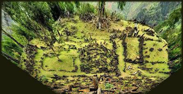
Corrected
perspective of Gunung Padang's Terrace 1 to creative an
overhead projection
(pic credit: Rodney Hale)
SOUTHEAST
ASIA'S LARGEST AND MOST ENIGMATIC MEGALITHIC COMPLEX. IS IT A PYRAMID HILL 12,000
YEARS OLDER THAN GOBEKLI TEPE?
Andrew Collins reports on the site of Gunung Padang in Indonesia's West Java province, reviewing recent proposals concerning its greater antiquity, and exploring the megalithic complex's orientation, alignment and suspected original function
Gunung
Padang, in Indonesia’s West Java province (coordinates: 107° 3'22.40"E
6°59'37.62"S), is seen as Southeast Asia’s largest and most enigmatic
megalithic complex. Located near the village of Karyamukti, some 20 miles (30
kilometres) from the city of Cianjur, and 55 miles (90 kilometres) from the capital
Jakarta, it consists of a series of rectangular stone enclosures with inner partitions,
walkways and gate entrances, as well as various rock mounds, all of them in a
ruinous state. They are constructed of naturally-forming andesite, i.e. basaltic,
pillars or columnar blocks (like those used in the construction of the ancient
city of Nan Madol close to the island of Ponope in Micronesia). The size of the
blocks varies between 25 centimetres and 40 centimetres in width and height, and
on average around 1.5 metres in length, with a weight of approximately 250 kilograms.
Some of blocks, which have either a roughly square or polygonal profile, are actually
much larger in size, with weights exceeding 600 kilograms.
The various
structures occupy five separate terraces, or courtyards, each linked by ascending
staircases marked with standing pillars. These terraces rise in steps to a height
of around 960 metres above sea-level, and cover an area of approximately 900 square
metres. These courtyards are accessed from the north-northwest via an ascending
staircase of 370 steps, which rises at an almost 45º angle. This starts in
the valley below, and from its base to the highest terrace it is about 90 metres.
Each terrace is positioned one in front of the other on a north-northwest-facing
hill formation that is volcanic in nature. Indeed, many geologists believe this
is the source of the andesite pillars used to create the stone settings, a fact
disputed in the light of recent discoveries (see below).
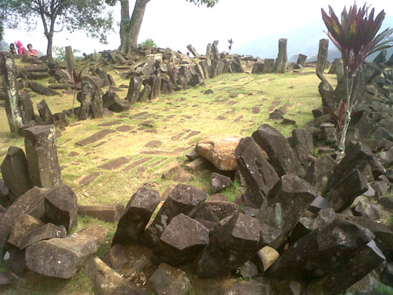
Gunung
Padang courtyard amd enclosure (Pice credit: Wiki Commons Agreement)
RADIOCARBON
DATES
The site was first mentioned in 1914, when it appeared in Rapporten
van de Oudheidkundige Dienst (ROD, “Report of the Department of Antiquities”).
It is mentioned again in 1949, within the work of Dutch historian N. J. Krom,
although it was not until 1979 that members of the National Archeology Research
Centre made a careful examination of its history, archaeology, and geology.
Conventionally,
archaeologists and historians place the construction of Gunung Padang’s megalithic
structures firmly within the Bronze Age, ca. 2500-1500 BC. However, geological
surveys conducted at the site since 2011 by Indonesian geologist Danny Hilman
Natawidjaja of the Indonesian Centre for Geotechnical Research suggest the monument
is much older – much older indeed.
Core
drilling samples and other exploratory excavations have uncovered evidence that
Gunung Padang is a multi-leveled structure, one phase being built on top of the
next, with evidence of activity on the hill at 22,000-20,000 BC, 14,700 BC, 9,600
BC, 4700 BC and 2800 BC, the final date being the age of the megalithic structures
visible today. Indeed, Danny Hilman and his team now believe that the entire hill
is an artificial pyramid of incredible antiquity. If correct, this would make
it the oldest built structure anywhere in the world. The ranges of dates cited
above derive from carbon-14 testing of organic materials taken from core drilling
samples extracted from a series of different depths.
Further evidence
of the artificial construction of the hill comes from the fact that Danny Hilman
and his team have uncovered series of andesite pillars laid down in rows beneath
the surface of the hill, and since andesitic pillars are only ever created vertically,
never horizontally, it means they must form part of an artificial construction
(often these andesitic, i.e. basaltic, columnar pillars are six-sided in profile
due to the rapid cooling process involved in their manufacture. See, for example,
those making up the Giant’s Causeway in Ireland. Those at Gunung Padang are
more irregular in profile).
CAVE SANCTUARY
With the prospect
that Gunung Padang’s megalithic complex is in fact a stepped pyramid as much
as 12,000 years older than Göbekli Tepe I felt the matter was definitely
worth investigating further. Yet having not had a chance to visit Gudung Padang
myself (I hope to go there next year), it is difficult to offer any constructive
comments regarding the hill’s proposed greater antiquity and apparent artificial
construction. However, if the radiocarbon dates can be shown to relate to human
activity, and are not simply the result of natural sediment accumulation on the
hill slopes, it is feasible that they are the result of Paleolithic peoples occupying
or visiting a natural cave site located at the heart of the structure. Indeed,
it might well be possible that the megalithic complex was built to surround an
existing cave sanctuary of immense antiquity (the exploration of caves and rock
shelters in eastern Java revealed evidence of occupation during the Upper Palaeolithic
age, approximately between 40,000 years ago and 15,000 years ago, see Peregrine
and Ember, 2001, 308).
Danny agrees with this theory. 3D geo-electric,
geo-magnetic and geo-radar surveys have revealed the presence of a hollow chamber
10 metres in width, height and length at a depth beneath the hill of approximately
25 metres. It apparently even has two doors in its hallway. He adds that the existence
of this suspected cave chamber was the most likely impetus behind the construction
of the multi-layered pyramid structure as early as the Upper Palaeolithic age.
This is supported by the organic samples extracted from this great depth, which
have produced radiocarbon dates in the range of 22,000-20,000 BC. Obviously, Danny
is anxious to explore these hollow cavities, although he must first gain permission
from the correct authorities to continue his exploration of the site (there is
considerable opposition against his explorations continuing at Gunung Padang.
Local people have protested using banners and placards, raising political and
religious issues that the Javanese government must address before the state-sponsored
survey can continue).
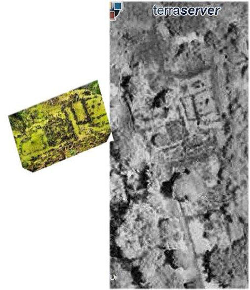
Terraserver image of Gunung Padang's terrace 1 (the lowest one) and corrected image (left) to show and overhead projection (Pic credit: Terraserver/Rodney Hale) | THE
MATTER OF ORIENTATION One matter I did attempt to examine with the help of chartered engineer Rodney Hale were the possible motivations behind Gudung Padang’s north-northwesterly orientation. I felt that if this could be established with some certainty it might provide a better understanding not only of the beliefs and practices of its megalithic builders, but also of its date of construction. The first thing we had to consider was the nature of the multiple stone settings, which are situated on five separate terraces or levels. Were these definitely orientated north-northwest, or might they in fact face toward the south-southeast? Rodney quickly determined that it could not be the latter, since the landscape rises considerably toward the south-southeast making it a very unlikely direction of orientation. In contrast the view to the north-northwest is unhindered, but for a single hill or mountain some 6 miles (10 kilometres) away. This rises to a height of approximately 1040 m, which is approximately 80 metres higher than Gunung Padang. Yet clearly visible beyond this hill when viewed from Gunung Padang is a double-peaked stratovolcano, which bears two names: Gunung Pangrango (its western peak, which rises to a height of 3,019 metres) and Gunung Gede (its eastern peak, which rises to a height of 2,958 metres). This lies at a distance of approximately 15 miles (24 miles) from the megalithic complex, clearly in view of the stone settings on all five terraces. |
That
Gunung Padang is aligned toward the Pangrango-Gede peaks is strengthened in the
knowledge that legend speaks of Gunung Padang being built by an ancient race that
came originally from this stratovolcano (personal communication with Danny Hilman).
Rodney Hale determined the mean azimuth of Gunung Padang’s megalithic complex
as 343-344º. This two-degree azimuth range targeted the eastern slopes of
the stratovolcano, which was a little disappointing as it meant there was no way
we could conclusively say that Gunung Padang targeted one or other of the volcano’s
peaks.
The matter bugged me, so I got together with Rodney to look at
the matter further. Both of us agreed that the north-northwesterly orientation
of Gunung Padang’s stepped terraces had to be toward the volcano. So we looked
once more at the axis of the various rectilinear stone settings and realized that
it was the structures on level one, the lowest of the five terraces, which seemed
to define the main axis of the site. This is determined by the placement of a
centrally positioned, and now collapsed rectangular rock mound on the east of
which is a long pathway that ends at the base of a stairway, marked by standing
megaliths, that climbs to the second level. The azimuth of both the rock mound
and the pathway by its side is 342º. This targets the main Gede peak, which
contains the volcano’s most notable crater, known as Gumuruh. This suggests
that the centrally-positioned rock mound, originally perhaps a viewing platform
used for ceremonial purposes, was the first construction on the terrace, the rest
of the stone settings most likely coming afterwards. Since the other stone structures
on the lower terrace display a varied assortment of azimuths ranging from 338-348º
they have created a false mean azimuth, which does not target any of the volcano’s
peaks.
| VOLCANIC
ERUPTIONS If all this is correct it does suggest that Gunung Padang’s megalithic builders saw the stratovolcano as central to their beliefs and practices, and constructed a viewing platform of andesitic pillars in order to watch it from a safe distance of around 15 miles. So the question arises: why focus your attentions on a volcano? The answer probably lies in the fact that the volcano has been periodically active across the past 10,000 years, with evidence of eruptions in around 10,000 BP (before the present), 4,000 BP, 1,200 BP and 1,000 BP (Belousov et al, 2012). It also erupted in 1840, with various other minor eruptions since that time. Currently, however, it is inactive. | 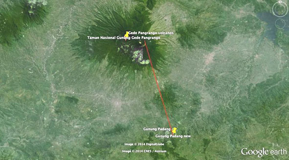 Line projection from gunung Padang towards the Pangrango-Gede stratovolcano (Pic credit Google Earth). |
Since
the rectilinear rock mound on Gudung Padang’s lowest level was directed toward
Gede’s main crater, or “stratocone,” called Gumuruh, it seemed
important to determine exactly when its 1.12 mile (1.8 km) wide caldera was formed.
However, organic samples from four different locations around the crater (including
a large debris avalanche deposit at its southeastern base) have only provided
dates earlier than 45,000 years ago, the limit for accurate Carbon-14 dating (Belousov
et al, 2012).
It is possible that the rock mound defining Gudung Padang’s
principal axis was built following a major eruption of the Gumuruh crater, perhaps
in order to honour or appease some kind of fire spirit or deity thought to inhabit
the volcano. Since the suspected eruptions before 45,000 years ago are clearly
too early to have had any bearing on building construction at the site, we should
consider the possibility that it followed one or other of Gede’s later eruptions,
mostly obviously those of 10,000 BP and/or 4,000 BP. However, these dates fall
outside the new radiocarbon evidence coming from the geological surveys carried
out at Gunung Padang, which feature the dates 22,000-22,000 BC, 14,700 BC, 9600
BC, 4700 BC and 2800 BC. So no more can be said on the subject at this time, other
than to assume that other eruptions might have taken place, which do correspond
with one or other of these dates.
The only thing we can say is that the
eruption of 4,000 BP corresponds pretty well with the conventional dating of Gunung
Padang’s megalithic complex to ca. 2500-1500 BC (or 2800 BC according to
the recent geological surveys conducted at the site). This might therefore have
some bearing on the orientation of some of the stone settings visible today. Yet
these, Danny Hilman is at pains to point out, simply reflect the final phase of
construction at the site, and that much older layers of building activity lie
deeper inside the hill.
FIRE AND FLOOD
One other point of
interest is that the indigenous peoples of Indonesia (such as the Bontoc and Igorot
populations), and also those of the Philippines, retain legends concerning a great
flood that once rose up and consumed the land. Only one human couple remained
alive afterwards, they having either climbed a mountain and/or sheltered inside
a mountain cave. About to die from a lack of warmth, the Great Spirit, Lumawig,
whose own two sons had caused the waters to consume the earth, goes either to
another mountain, or somewhere elsewhere on the same mountain, and fetches them
fire. This burns so brightly and with such ferocity that it evaporates the floodwater,
making the world dry again. By this time the woman has become pregnant, and so
she becomes the progenitor of the next human race, who go on to repopulate the
world (Perry, 1935, 96-98; Bacwaden, 1997, 3-49; and “Fire and Flood: An
Igorot Folk Tale,” http://multoghost.wordpress.com/2014/04/02/fire-and-flood-an-igorot-folktale/”).
The connection with an all-encompassing deluge is tantalizing, and might be
based on the memory of a real event in recent geological history. Although there
is simply not enough information in this catastrophe account to connect it with
a specific event, one cannot help but think about the Younger Dryas Boundary impact
event of ca. 10,900 BC. This suspected comet impact, which I detail in my book
Gateway to Atlantis (2000), and also in new book Gobekli Tepe: Genesis
of the Gods, is thought to have brought about widescale wildfires, super tsumanis,
as well as a long period of darkness, caused by a dense ash cloud. This in turn
triggered a 1,300-year mini ice age known as the Younger Dryas event. Interestingly,
the catastrophe account cited above says that immediately before the two sons
of Lumawig caused the waters to well up and consume the world “the sky darkened”
(Bacwaden, 1997, 6).
Perhaps connected is that fragments of the comet
that impacted with the North American continent are speculated to have caused
the water locked up in the ice sheets of the Great Lakes region to instantly vapourise.
This water would then have fallen back to earth as torrential rain for an extended
period of time, causing considerable flooding and a rapid rise in the sea level.
On top of this, the Younger Dryas impact event produced a thick ash layer, known
to science as the Usselo horizon, which has been detected in the geological record
right across Europe, and as far away as Egypt, Southwest Asia and even Australia.
So there is every reason to suspect that this event might have had some impact
on the Indonesian landmass. Perhaps it even triggered eruptions of the Pangrango-Gede
stratovolcano.
APPEASING THE SPIRITS
Whatever the basis behind
these catastrophe myths, they provide a suitable reason behind the veneration
of fire among the megalithic builders of Indonesia, who have left behind a wide
variety of quite extraordinary stone settings throughout the region (see W. J.
Perry’s essential tome The Megalithic Culture of Indonesia, published
in 1918, although it makes no mention of Gunung Padang). The Great Spirit Lumawig’s
direct association with the procurement of fire on behalf of the flood survivors
is also interesting, and might just refer to the activities of a volcano active
at the time of the aforementioned cataclysm. Once again, this could have some
bearing on the interest shown by the Gunung Padang megalithic builders in the
Pangrando-Gede stratovolcano, enough for them to orient their entire monument
towards one of its peaks. Was Gunung Padang constructed in response to some kind
of global or regional catastrophe? Did the local population believe they needed
to appease the Great Spirit, some kind of local form of Lumawig, in order to prevent
future cataclysms? Did they associate this deity with the stratovolcano’s
fiery emissions, and periodic eruptions?
These are interesting ideas that we
can explore in order to gain a better picture of Gunung Padang’s original
function, and perhaps even its greater antiquity. Perhaps a study of the legends
and folklore surrounding Gunung Gede might also pay dividends. For instance, I
read that:
This Park [that is, the Gunung Gede Pangrango-National Park]
is surrounded by ancient superstitions and beliefs. Legend has it that the spirits
of Eyang Suryakencana and Prabu Siliwangi [local saints] guard Mt. Gede to keep
it from erupting. Even now, at certain times of the year, people flock to the
caves around Mt. Gede to meditate or hold ritual ceremonies (see http://www.dephut.go.id/uploads/INFORMASI/TN%20INDO-ENGLISH/gedepangrango_NP.htm).
These statements alone suggest that in Java the appeasement of local spirits
and deities is necessary to prevent eruptions of the stratovolcano, a matter that
cannot be unconnected with Gunung Padang’s orientation toward Gunung Gede.
The mention also of caves in which people flock to meditate at certain times of
year echoes the manner in which the progenitors of the current human race emerged
from a mountain cave in the wake of the all-encompassing flood.
ASTRONOMICAL
ALIGNMENTS?
Rodney Hale did look at potential astronomical alignments
based on Gudung Padang’s proposed axis of 342º (that is, toward the
main Gede crater), and, using the proposed radiocarbon dates offered by the recent
geological surveys, found the following possible ground-sky correlations:
21,000 BC – setting of Cassiopeia.
20,000 BC – setting Polaris
in Ursa Minor.
14,900 BC and again in 8750 BC – setting of Vega in Lyra.
12,450
BC – setting of the Cygnus star Deneb and the opening to the Milky Way’s
Great Rift, or Cygnus Rift.
5200 BC to 600 BC – the setting of various
stars belonging to Ursa Major* and Ursa Minor. Alioth in Ursa Major fits well
twice in this time frame.
2800 to 2700 BC – Dubhe of Ursa Major.*
*In Indonesian star-lore Ursa Major is a
constellation of some importance known as Bintang Biduk,
which means “Biduk star.” A biduk is a boat or canoe (see below).
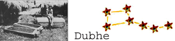 In Indonesian star-lore the constellation of Ursa Major was known as Bintang Biduk, the "Biduk star". A biduk is a boat or canoe, like those in the photograph on the left, which shows an Igorot tribesman next to wooden "biduk," in this case canoes. The first ancestors of the Toraja people of Indonesia were said to have descended from the sky. Other traditions have them arriving by boat from the north, the two stories becoming inextricably weaved together over time. Even today the Toraja build saddle-roofed houses to emulate the boats in which the sky gods first arrived from the stars. |
The problem with all these ground-sky correlations is that they are meaningless
until Gudung Padang’s exact age of construction can be established with absolute
certainty. This can come only from a full excavation of the site, something that
might hopefully reveal evidence of the material culture behind the construction
of Gudung Padang. If, as claimed, the site does date back to the Upper Paleolithic
age, ca. 22,000-9500 BC, then its builders will have left behind masses of stone
tools made, used and discarded during the creation process at the site. We see
this at terminal Paleolithic, or proto Neolithic sites, such as Göbekli Tepe
and Karahan Tepe, where even to this day thousands of stone tool fragments lay
scattered about.
Tens of thousands (possibly even millions) of stone tools
were found also in the famous 50,000-year-old haematite mines of Bomvu Ridge in
the Ngwenya massif of Swaziland. It is the same everywhere you go, right the way
back to the earliest settlements at Oldavui Gorge in Tanzania. As early as two
million years ago our ancestors were discarding inordinate amounts of worked stone
tools, which provide an accurate means of dating a site contextually. So far no
Paleolithic stone tools have been found at Gunung Padang. When they are, this
will help settle the debate once and for all regarding the greater antiquity of
this amazing place, which, I suspect, is going to be the subject of controversy
and debate for some years to come.
Bibliography
Bacwaden, Joy Christine O. “The Lumawig Bontoc Myths.” Philippine
Studies 45: 1 (1997): 3–49.
Belousov, A., M. Belousova, A. Zaennudin,
and Prambada, O. “Volcaniclastic stratigraphy of Gede volcano in West Java.”
American Geophysical Union, Fall Meeting 2012, abstract #V41B-2790 (December 2012),
http://adsabs.harvard.edu/abs/2012AGUFM.V41B2790B.
Peregrine,
Peter M., and Melvin Ember. Encyclopedia of Prehistory, vol. 3: East Asia and
Oceania. New York, NY: Springer, 2001.
Perry, W. J., The Megalithic
Culture of Indonesia. Manchester: Manchester University Press, (1918) 1935.
Thanks go out to Danny Hilman and Rodney Hale for their help in enabling
me to compile this preliminary report of Gunung Padang. Thanks also to Catherine
Hale for her editorial suggestions.