![]()
![]()
Stonehenge
Healing
Sanctuary Facts and Fiction,
and a New Mesolithic Mystery
Countering
claims that Stonehenge was a healing centre, a Neolithic Lourdes. Reviewing the
site's Mesolithic mystery, and
Unravelling the Alignments of the Avenue.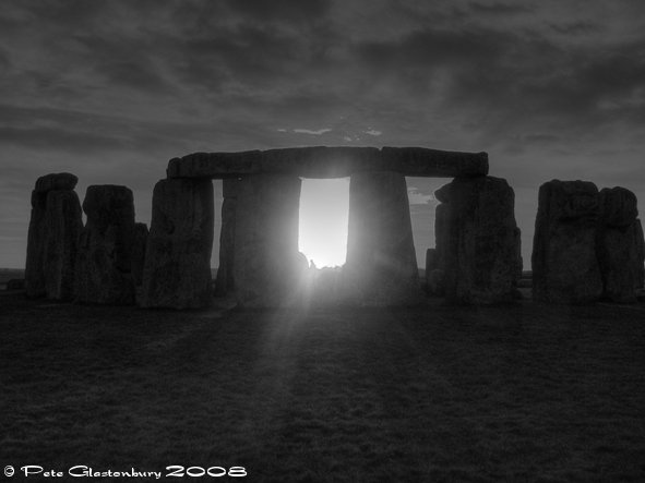
A
Special Report by Andrew Collins
Part One - Don't Believe the Hype
Stonehenge is back in the news following claims that its famous ring and horseshoe of four-tonne bluestones, carried all the way from the Preseli Mountains in South Wales, acted as a healing sanctuary for the sick and infirm some 4,300 years ago. The theory, put forward by Professors Timothy Darvill of Bournemouth University, and Geoffrey Wainwright, both key members of the Society of Antiquaries, comes following an English Heritage sponsored excavation, the first inside Stonehenge for 44 years.
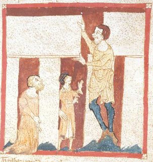
Geoffrey
of Monmouth
Darvill and Wainwright's thesis began with a few lines from Geoffrey of Monmouth's often maligned magnus opus The History of the Kings of Britain, written c. 1136 AD. In it Merlin the wizard tries to convince the ancient Britons to invade Ireland in order that they might dismantle and bring back to Britain a megalithic monument known as the Giant's Ring, as its stones are said to have been connected with "certain secret religious rites and they have various properties which are medicinally important."
The text goes on to say that "whenever they [the Irish] felt ill, baths should be prepared at the foot of the stones; for they used to pour water over them and to run this water into baths in which their sick were cured. What is more, they mixed the water with herbal concoctions and so healed their wounds. There is not a single stone among them which hasn't some medicinal virtue."
Assuming that the Giant's Ring became Stonehenge, and the healing stones are its bluestones, Darvill and Wainwright propose that this healing cult was thus transferred from the Preseli Mountains of South Wales to Salisbury Plain. Moreover, they argue that bluestone was anciently seen to have curative properties, and that if brought into contact with water could cause it to be used for healing purposes.
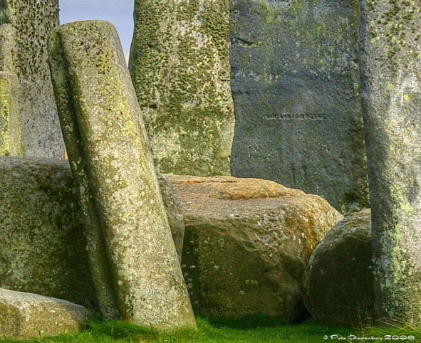
One of Stonehenge's bluestones (Copyright: Pete Glastonbury 2008).
Healing
Sanctuary
Among the evidence that Darvill and Wainwright cite
in support of their theory is the fact that large quantities of bluestone chips
were found during their excavations. Indeed, they say the number of bluestone
chips far outweighed that of the sarsen chips, leftover after the construction
of Stonehenge's more familiar trilithons and outer circle, which make up its famous
outer ring of uprights and lintels.
Yet none of this proves that the bluestone chips had any greater significance, only that more were left behind after the completion of the monument. Moreover, if bluestone did have some kind of special power, then surely people would have taken them away from the site, leaving behind a higher ratio of lesser important sarsen chips.
Darvill and Wainwright state that very few bluestone chips were found close to the surface, showing that visitors seeking cures have taken them away because of their healing properties. However, it might equally be said that people have been taking away stone chips from Stonehenge, quite simply as souvenirs, whether blue stone or sarsen fragments.
Another claim is that among the human burials unearthed in the various Bronze Age cemeteries around Stonehenge there is an excess of bones showing that the individual suffered from some kind of disabilitating sickness or malady. Moreover, that the oxygen levels present in various teeth examined show that their owners came from various parts of the country, and thus had come to Stonehenge in an attempt to heal themselves.
In response to this, it might be said that if you searched any ancient or more modern cemetery you are going to find a high percentage of human remains with clear evidence of some kind of illness or malady. Even if people did descend on Stonehenge from different parts of Britain, this might not have had anything to do with seeking cures to illness. It could equally be that the site was recognised as a place for the burial of the dead, like Westminster Abbey, or Highgate cemetery. There is no need to assume that the place of burial of the dead was also a healing sanctuary. Indeed, a large number of burials were made around Stonehenge as early as 3300 BC, some 350 years before Stonehenge phase I, c. 2950-2900 BC.
Amesbury
Archer
Darvill and Wainwright also focus their attentions on the so-called "Amesbury Archer", a burial discovered in 2002 at Amesbury, just three miles away from Stonehenge. His remains show evidence of an impact fracture to one knee, which never properly healed. Darvill and Wainwright propose that the injury was most probably caused when the man was thrown from his horse, making it difficult for him afterwards to walk. They also point out that his jaw shows evidence of a ruptured abscess due to acute tooth infection. The pain from this would have been excruciating, leading eventually to his death.
In the knowledge that the levels of oxygen found in his teeth suggest that the Amesbury Archer lived at high altitudes, Darvill and Wainwright speculate that he came originally from the Alps of Switzerland, and after sustaining his injuries journeyed immediately to the only place he might hope to find a cure - Stonehenge, in far off Britain. However, on arrival here, the tooth ruptured, causing his death, the reason why he was interred locally, seemingly with a son, who was buried alongside him. If such a scenario were to be proved correct, then according to Darvill and Wainwright it means that the bluestone circle had to have been in place by around 2300 BC, the date ascribed to the Amesbury Archer following radio-carbon testing of his remains. This goes against current archaeological thinking which insists that the bluestone horseshoe and ring were not erected until around 2000 BC.
There is no realistic evidence that the Amesbury Archer either came from the Alps or was a horse rider. Even if he did come from the Alps, the chances are that he arrived in this country as part of a much bigger social group. His high status burial, alongside that of his "son", suggests that he was a leader of some kind, and may well have been the ruler of a large community, or even a tribe. Moreover, such speculation cannot allow a redating of the bluestone circle simply to comply with personal theories.
Bluestone
Chips
Darvill and Wainwright also claim that a bluestone chip was found among the Amesbury Archer's possessions, adding weight to their conviction that such chips were highly prized as healing objects. However, I am told that those archaeologists who were present when the body was uncovered and removed say they have no recollection of a bluestone chip being found. Certainly, it does not appear in any published paper on the subject.
The discovery of further bluestone chips, one in a long barrow nearby to Stonehenge called Bowl Barrow, one at West Kennett long barrow and another one found in the 1960s on the top of Silbury Hill, is seen as further evidence of this theory. Moreover, the existence locally of various springs is cited as yet further proof that Stonehenge was a Neolithic Lourdes, since these would have provided the water necessary for the assumed healing ceremonies, whereby water would have been poured over the stone or, alternatively, a piece of bluestone would have been immersed in water in order to imbue it with healing qualities.
Yet if such a powerful healing cult had existed at Stonehenge, then it is likely that evidence of its existence would have persisted among local folk beliefs and practices. However, no such practices are known in Wiltshire, either in connection with standing stones or holy wells. There was a more general belief recorded in the nineteenth century that Stonehenge had healing qualities, with visitors taking away pieces of stone. However, there is no evidence that this tradition was ancient or specific to Stonehenge. Indeed, it most probably began in the eighteenth century with the rise in popularity of health spas across Europe. Many other standing stones and stone circles around the country have similar attributes, such the Men-an-Tol monument in Cornwall, where individuals inflicted with crick, or rheumatism, would crawl through its holed stone in the hope of being cured.
Darvill and Wainwright cite as evidence for the connection between bluestone and holy water the fact that holy wells in South Wales, the sole possible source of the bluestone used in the construction of Stonehenge's horseshoe and ring, as occasionally having pieces of bluestone placed at their mouths, some decorated with carvings. However, there is nothing in Welsh folklore to suggest that the stones were there to enhance the water's curative properties. Moreover, standing stones, stone altars and carved stones in general were often found in connection with Welsh holy wells, yet their placement was not known to have been due to any special quality attributed to the stone itself (see Francis Jones, The Holy Wells of Wales, Univ of Wales Press, Cardiff, 1954, pp. 14-18).
Merlin's
Story
Even the original story from Geoffrey of Monmouth's History about pouring water over the stones at Stonehenge might be a misnomer, for it is possible that the new site of Ireland's Giant's Ring was not Stonehenge at all, but Avebury, a much larger stone circle complex located some 30 miles to the northwest.
Merlin
erect's the Giant's Ring | Merlin convinces the ancient Britons to raid Ireland and bring the Giant's Ring back to "Mount Ambrius", which is assumed to refer to Amesbury, an ancient monastic town just 3 miles from Stonehenge. However, there is no obvious candidate for any such 'Mount' around Amesbury or Stonehenge. Moreover, Lewis Thorpe, the translator of Geoffrey of Monmouth's History, offered the alternative view that Avebury, and not Stonehenge, was meant by "Mount Ambrius" (see Geoffrey of Monmouth, History of the the Kings of Britain, 1966, p. 195 n. 1). If Avebury was meant, then nearby Silbury Hill, the largest manmade mound in Europe, becomes a likely candidate for "Mount Ambrius". |
Adding weight to this idea is that in the nearby town of Marlborough, just 6.5 miles from Avebury, is Merlin's Mound, an ancient castle mound constructed, like Silbury, in the Late Neolithic period, c. 2400-2000 BC. Folklore dating back to the early thirteenth century cites it as the burial place of Merlin. Even though this connection with the wizard might simply have been born from the similarity between the name Merlin and the oldest forms of the Marlborough place-name: Merleberge (1086 DB), Marleberge (1091) and Mærle beorg (1150), from earlier Mærlanbeorg, the 'the barrow of one Mærla' (Gover, Mawer and Stenton, The Place Names of Wiltshire, CUP, 1939, s.v. "Marlborough", 297-98), the fact that the legend existed within just 80 years of Geoffrey writing his History is intriguing. It is tempting therefore to suggest that Marlborough's connection with Merlin might have predated Geoffrey's History, and, if so, could have helped inspire the story linking Merlin and the Giant's Ring with Mount Ambrius.
The name "Ambrius" is quite likely a condensed form of the name Ambrosius, an allusion to the Romano-British war leader Aurelius Ambrosius (or Ambrosius Aurelianus), who fought and won various battles against the Anglo-Saxons in the fifth century, immediately prior to the age of Arthur. Aurelius's early life somehow became confused with that of Merlin the magician, even by Geoffrey's day, leading to the wizard's dual name of "Merlin Ambrosius". Thus it is possible that Merlin's Mound, located out of sight within the grounds of Marlborough College, is the best candidate for a historical Mount Ambrius, and not Silbury. Curiously, the oldest form of the name Avebury is Aureburie (1086 DB), which has faint echoes of the name Aurelius Ambrosius, who some believe was responsible for creating the Wansdyke defensive ditch, which runs from Andover in Hampshire to Portishead near Bristol (and passes just to the south of Silbury Hill and Marlborough).
In conclusion, there seems to be very little hard evidence that Stonehenge was the Lourdes of its day, or the A & E of southern England as Darvill and Wainwright wish us to believe. Indeed, that English Heritage have so easily embraced and promoted these wild speculations, which were exclusively featured in a recent BBC "Timewatch" special, implies that this Government-run body are intent on creating the right image for Stonehenge in time for the 2012 London Olympics. It will be then that Britain's premier ancient monument will come under the spotlight of the entire world, and the view that it was once a healing sanctuary is far more acceptable to modern alternative/new age trends than the currently held view - accepted by most - that it was a centre for the Neolithic cult of the dead, as well as a Neolithic astronomical observatory. So, you have been warned, DON'T BELIEVE THE HYPE!
Part
Two - Stonehenge's Mesolithic Mystery
The worldwide publicity Stonehenge has received following claims that it functioned as a Neolithic healing sanctuary has overshadowed more important discoveries being made regarding the site's much greater antiquity. As far back as 1968 rescue digs in the area of the present car park, NW of the henge monument, revealed the presence of four extremely large post holes that had once contained gigantic posts made of pine (three of these holes are today marked by circular white markers visible against the dark tarmac). The fact that the posts were of pine and not some more readily available deciduous tree, of the sort that proliferated in the forests of Britain during Neolithic times, baffled archaeologists until radio-carbon dating of the pine wood revealed dates in the region of 8000 and 6500 BC, at least 3,500 years earlier than Stonehenge phase I. In other words, the existence of the post holes implied that there had been activity on the site of Stonehenge as early as the so-called Mesolithic era, the transitional stage between the hunter-gatherer societies of the Late Palaeolithic epoch, which in Britain ended c. 8000 BC, and the start of the Neolithic age around 4000 BC.
For years the evidence offered by the car park post holes, which seem to form a slight crescent facing away from Stonehenge, was virtually ignored by mainstream archaeologists, simply because it made no sense to the site's known evolution. It was then proposed by British astronomer C. A. "Peter" Newham, a friend and colleague of Sir Fred Hoyle, that the posts marked solar alignments along with phases in the 18.61 lunar standstill cycle, as viewed from the position of the henge monument. Yet the implications of this were simply too much for current archaeology to handle, for if such theories were correct then it meant that Stonehenge had been an astronomical observatory as early as 8000 BC. This was impossible, since no other Mesolithic cult centres were known to exist anywhere in Europe. You would have to go to SE Turkey and sites such as the Pre-Pottery Neolithic cult centres at places such as Nevali Cori and Gobekli Tepe, which date to c. 10,000-8000 BC, to find anything even remotely similar from this same epoch.
Darvill and Wainwright's excavations have confirmed that the area on which the Stonehenge monument is situated was cleared for use as early as c. 7200 BC, some 4,000 years earlier than Stonehenge phase I, when the site's circular ditch and bank were constructed, c. 2950-2900 BC, with a ring of 56 posts inside them (these are today known as the Aubrey Holes after their discoverer John Aubrey, who first noted their existence in the seventeenth century).
More
Mesolithic Evidence Exclusively Revealed
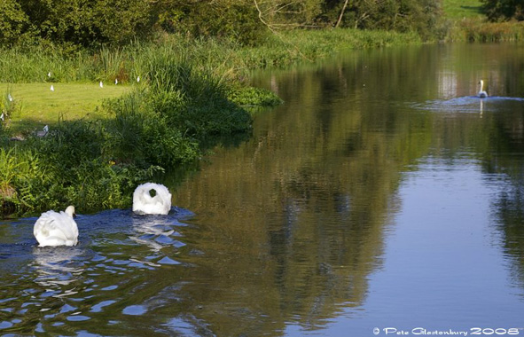
Adding further weight to the idea that Stonehenge is many thousands of years older than anyone had ever imagined is new evidence uncovered during recent excavations of the so-called Avenue. This is the linear trackway that leads away from Stonehenge in the direction of the summer solstice sunrise (or leads to Stonehenge in the direction of the winter solstice sunset), before turning on to a roughly easterly course, and then finally swinging SSE to end by the banks of the River Avon, three miles away in West Amesbury.
During the final week of excavations, the archaeological team discovered a large scatter of Mesolithic worked flints exactly on the Avenue. What is more, underneath them quantities of Palaeolithic flints were found, showing a continuity of usage through from this earlier age to the Late Bronze Age. Radio-carbon dating of organic materials found in association with the flint scatters is expected soon, although speculation is rising that the original course of the Avenue is Mesolithic in origin. The presence of the Palaeolithic flints, which could date to anywhere between 15,000 and 8000 BC, is much more of a mystery for which speculation would be inproper at this time.
Part
Three - Stonehenge Alignments
Stonehenge's
Avenue ends at a long straight section of the River Avon (the name "Avon"
comes from afon, the Welsh word for "river"), which since time immemorial
has been used as a runway for swans to take off and land. Indeed, cygnets learning
to fly can take as much as 100 metres to lift into the air during their first
attempts at flight. Following the recent excavations, it was suggested to me that
there might well some connection between Stonehenge's cult of the dead, the orientation
of the Avenue, especially its final section, and the Cygnus constellation.It was
a suggestion that appealed to me, since I had already looked at Stonehenge for
possible astronomical alignments featuring Cygnus.
| One in particular stood out featuring the rising of Deneb, Cygnus's brightest star, around 5000 BC. This was based on the star extinguishing at approximately 2 degrees at an azimuth of 342-degrees, the axial orientation of the two so-called Station Mounds at the NNW and SSE extremes of Stonehenge's outer circle, on which were located stones nos. 92 and 94. These stones, along with two others Station Stones (nos. 91 and 93), form part of what is known as the Station Stone Rectangle, which is perpendicular to the monument's ENE-WSW solstitial alignment. |
Swans parading on the River Avon at West Amesbury. |
Even though Peter Newham proposed that the Station Stones featured in solar and lunar alignments marked by the Mesolithic posts in the car park, I had disregarded this Cygnus alignment. This was because there was no known evidence to date the two mounds any earlier than Stonehenge phase I, c. 2950-2900 BC. Yet this new evidence that the site was cleared for usage as early as c. 7200 BC increases the chances that the Station Stone mounds might be older than is currently believed. What is more, they might well have defined the site's earliest orientation, providing a NNW-SSE axis through its centre point, in similar with that found at both Avebury and Stanton Drew. Speculation that the Avenue might also be Mesolithic, due to the recent discovery of the flint scatter close to the River Avon, also increases the likelihood that some form of structure existed on the site of the henge during this same epoch.
I thus looked at all three sections of the Avenue for a variety of dates, with the results given below. In summary, what they indicate is that the first section, leading away from Stonehenge, was aligned to either the summer solstice sunrise (or the winter solstice sunset) for a date of around 5000-4000 BC. At the same time, the second section might easily have been aligned towards the Milky Way, when standing vertical on the horizon. The third and final section down to the River Avon was aligned, if looking NNW, towards the setting of Deneb, Cygnus's brightest star, c. 5000 BC. However, these alignments, even if meaningful, must be taken simply as observations, with more precise information needed on azimuth bearings, and dating evidence, before the matter can be taken any further. Regardless of whether the Cygnus alignments at Stonehenge are meaningful, a possible connection between its proposed cult of the dead and the rich mythology attached to the swan, or indeed other water birds, is highly probable.
Possible carvings of a swan's head and neck appear in two places on stones in Avebury's Kennett Avenue, while the bones of a large bird, possibly a swan, were found in a large mound called Hatfield Barrow at Marden, next to the River Avon near Devizes, by antiquarian William Cunnington in 1807. Moreover, near Pewsey, which is also on the River Avon, regular folk moots were held on a Bronze Age barrow (now no longer there) called Swanborough Tump, which perhaps derives its name from an Anglo-Saxon root meaning "swan's mound".
In Pewsey's church of St John the Baptist, "goose" feathers were found in 1800 during restoration work. They were concealed inside a small stone-cut recess located on the west face of the pier closest to the north door (some of the feathers remain on display within the original recess, which is now behind a glass window). It was assumed at the time that they were medieval relics, perhaps thought to be feathers dropped by the archangel Gabriel when in the Temple. However, the proximity of the recess to the north door, and the fact that graffiti showing a goose can be seen on a pillar in the same position in the church at Waltham St Lawrence, Berkshire (see Michael Bayley, Caer Sidhe, vol 1: The Celtic Night Sky, Capal Bann, Chieveley, Berks, 1997, p. 60, and personal enquiries) tends to suggest that the interment of the feathers relates more to the ancient folk belief that the soul ascended towards a northerly-placed heaven in the company of, or in the form of, a swan or goose, both of which were anciently associated with the Cygnus stars. It is extremely likely that migratory swans and geese had some influence over the Neolithic cult of the dead at Wessex ritual complexes such as Avebury and Stonehenge, local rivers, such as the Kennett and Avon, acting as physical representations of the Milky Way, universally seen as a river or road used by the dead to reach a northerly placed sky-world. Watching out for further evidence of bird bones in Neolithic and Bronze Age burials might pay dividends, helping us to better understand the symbolism associated with this cult.
Conclusions
I think we have much more to learn about Stonehenge, and this new knowledge that it has a history spanning at least 10,000 years is marvellous news, confirming it as Britain's oldest sacred site. And remember, don't believe the hype in the lead up to the 2012 Olympics!
Special Thanks to Pete Glastonbury for his help in putting together this article, and also for the use of his photographs.
All photographs are copyright Pete Glastonbury 2008.
Appendix
- Avenue Alignments
Stonehenge Avenue has three azimuths for its three sections from Stonehenge to the River Avon:
Section one
- 49/229 degrees
Section two - 97/277 degrees
Section three - 339/159 degrees
(Correct to within +/- 0.25 degrees)
Section one is unquestionably a solar alignment either towards the summer solstice sunrise, which has the following maximum azimuths for the visibility of one half of the sun's disc, with changes caused by the obliquity of the ecliptic:
49
12 degrees sun's most northerly 3000 BC
48 59 degrees sun's northerly extreme
4000 BC
48 55 degrees sun's most northerly 5000 BC
48 50 degrees sun's most
northerly 6000 BC.
This suggests that the older dates work better for the alignment, particularly 5000 BC.
Clearly, the alignment could equally have been towards the winter solstice sunset.
Section two could have a solar component. Sunrise at 97 degrees falls firstly between the February cross quarter day and the spring equinox and again between the autumn equinox and the November cross quarter day.
The only possible stellar alignment is to the Pleiades for 3000 BC, although it would only work if the local horizon is very high, approximately 4-5 degrees.
Pleiades 97 degrees azimuth
3000 BC - 5 degrees elevation
There is no relation for earlier periods.
At 277 degrees, the only stellar alignment is to the Milky Way which is erect in the night sky from the constellation Scutum up to Aquila and Cygnus. This works for anywhere between 3000 BC and 5000 BC.
Section three of the avenue, which comes up from the river, if stellar aligned would be towards Deneb (Alpha Cygni), if facing NNW. If facing SSE, there is some correlation to Alpha or Beta Crux, the Southern Cross. Date wise, the NNW-Cygnus alignment works best around 5000 BC (as with the mounds alignment in the rectangle). Cygnus was seen to set during this epoch during the winter months.
For the SSE-Alpha Crux alignment to work, a date between 4000 and 5000 BC would be required.
Deneb (alpha Cygni) at 339 degrees azimuth:
0.45
degrees 3000 BC
1.20 degrees 4000 BC
2.46 degrees 5000 BC
3.5 degrees
5500 BC
5.4 degrees 6000 BC
Mimosa (Beta Cruz) at 159 degrees azimuth
3000 BC 1.38 degrees
Alpha Cruz at 159 degrees azimuth:
4000
BC 1.28 degrees.
5000 BC 4.21 degrees
No other stars related to the azimuth for the third section, and it is too far north for a solar or lunar alignment.
All of these alignments are based on zero to 2 degrees local horizon. Any higher and recalculations would need to be made.
The
azimuths of the Avenue were determined using the OS Landranger series, 1:50,000
scale.
![]()
|
Origins |
![]()